National Grid References
All Ordnance Survey maps, irrespective of scale, use the National Grid Reference system for identifying any point on a map. This system basically overlays the map with a grid of blue squares with numbers going round the border. Each square on a 1:50000 map is 2cm x 2cm and covers an area of 1 sq Km, on a 1:25000 map each square is 4cm x 4cm covering the same area.
A National Grid reference for any point normally comprises six digits and are always read eastwards, also known as Eastings because the numbers increase as you move east on the map, before reading northwards, also known as Northings because the numbers increase as you move north on the map. Eastings comprise digits 1-3 and northings comprise digits 4-6. The National Grid reference must always be recorded in the same number of figures, even if some are zero. eastwards, also known as Eastings because the numbers increase as you move east on the map, before reading northwards, also known as Northings because the numbers increase as you move north on the map. Eastings comprise digits 1-3 and northings comprise digits 4-6. The National Grid reference must always be recorded in the same number of figures, even if some are zero.
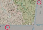
The numbers going around the border of the map correspond to the first two digits of the Eastings and Northings, these are highlighted by the red circles in the example. The third digit is derived by further sub-dividing each square into an imaginary 10 x 10 grid. If you look around the border of the map, you should see that there are divisions already marked for you that will enable you to locate any point to within 100 metres, as you may see on the example. Clicking any example on this page will open a larger view for clarity.
Some grid references are preceded by letters or numbers and this relates to the particular map being used, e.g. OL6/321906. In the this example, this refers to OS Map Outdoor Leisure 6, denoted by the first two digits and covers the 1:25000 map The English Lakes South Western Area in England.
How to read Grid References
In this example we’ll find what is at grid reference OL6/321906 to the nearest 100 metres.
We know that OL6 refers to OS map Outdoor Leisure 6 which covers The English Lakes South Western Area.
The next six numbers are further broken down into two sets of three, e.g. 321 and 906 which refer to the eastings (321) and northings (906). Remember eastings go across the page whilst northings go up the page.
To find the location of the place at the grid reference on this map you have to follow the process below.
Eastings
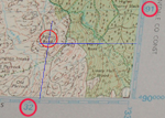
Take the first two digits of the eastings (32) and find the number across the bottom of the map that corresponds to this number. You want the box to the right of this reference. Now take the third digit of the eastings (1) and go across to the first division of this box, remember this point and you're half way there.
Northings
Now take the first two digits of the northings (90) and find this number up from the bottom of the map that corresponds to this. You want the box above this reference. Now take the third digit of the northings (6) and go up to the sixth division of this box.
The Location
Trace an imaginary line from the point you remembered from the eastings up the map until it crosses with an imaginary line coming across the map from the northings point you have just located. Where the two lines cross is the location of the place identified by the Grid Reference to the nearest 100 metres. In this example it is the location of Penny Bank.
|